Tuesday, July 5, 2011

Manitoba


The province of Manitoba is locate in the centre of Canada, in the prairie lands. It stretches from the Hudson Bay, all the way down to the US border, and encompasses Lake Winnipeg. Which is also its largest city, and capital.


Originally many First Nation tribes settled the area after the Ice Age retreated, with the first European arriving in 1611 with Henry Hudson, who gave his name to the bay. He was subsequently abandoned there by his crew. In 1612, Sir Thomas Button reached central Manitoba in an attempt to save Hudson. 

That voyage led to the formation of the Hudsons Bay Company. The company acted as the de facto government and authority across large swathes of Manitoba through its network of trading posts. Hudsons Bay Company traded with the explorers bringing in needed supplies, and buying furs from the First Tribes. As the fur trade declined, the Hudsons Bay Company took to expanding their import/export side.

The Company, as it was the de facto authority, was granted the right to use the red ensign in 1689. It was defaced with the company initials in white on the lower fly of the flag. The letters consist of the H and B interlocked, with the "C" separate.


Manitoba was originally part of Prince Ruperts Land, and the territory was ceded to Canada in 1869. After the Manitoba Act introduced into the Canadian Parliament, Manitoba was formally a province of Canada in 1870. The original province of Manitoba was much, much smaller than it is today. In 1881, Manitoba expanded, only for large parts of its land to be handed to Ontario after Ontario claimed large chunks of it. Never the less, Manitoba continued to gobble up chunks of land from the Northwest Territories until it attained its current size in 1912.

The flag itself continues the use of the Red Ensign which had been in use in Canada as its national flag. Also, it was a nod to the regions history whilst it was under control of the Hudsons Bay Company which also used a red ensign. 

With the adoption of the new Maple Leaf flag for Canada, Manitoba took the decision to introduce a new flag. In 1965 a bill was passed on May 11. Queen Elizabeth gave permission in October, and the new flag was formally adopted in 1966. 

The new flag is the Red Ensign with the shield of Manitoba taken from the Coat of arms placed n the lower fly of the flag. 

The shield was granted to Manitoba by King Edward in 1905. The shield consists of the St George Cross at the top. Underneath, is a buffalo. A symbol of Manitoba's prairies.


In 1992, a Vice-Regal warrant was granted to augment the shield to include its supporters, crest and motto.


The supporters are a white horse, and unicorn. Featuring red and white beadwork, and a Red River wheel. The compartment consists of examples of Manitoba's diverse landscape. On top is a gold helmet, facing left. The mantling is red and white, the national colours, and the crest is a beaver, the national animal. The beaver is holding a prairie crocus, the national flower. The crest itself is surmounted with a crown, representing Royal sovereignty.


Monday, July 4, 2011

Labrador


Labrador forms part of the Province of Newfoundland and Labrador. Newfoundland and Labrador consists of 2 parts. Newfoundland, a triangular shaped island in Canada's far east, and Labrador forms the triangular shaped territory next to Newfoundland on the mainland. 


Originally, Labrador was held by the French, but after the Treaty of Paris in 1763, the territories of "New France" where ceded to British control. Once Britain had finally taken full control, and quelled any troubles from the Francophone population who objected to British rule, the territories of what where now Lower Canada where divided up and became parts of the provinces of Quebec, and Newfoundland.

The Canadian Confederation was originally formed in 1867, with Quebec, Ontario, Nova Scotia, and Prince Edward Island uniting to form the first real "Canada." The rest of the territories joined this nascent Canada over the following 40 years, with Alberta and Saskatchewan joining in 1905. 

Newfoundland held out. 


The border between Labrador and Quebec (part of Canada) was not settled until 1927. Canada insisted that the border to Labrador essentially existed as a 1 mile strip along the coast. Needless to say, Newfoundland objected. Since both where part of the British Empire, the final decision was made by the Privy council in London, which fixed the border as it is today.

As part of Newfoundlands negotiations with Canada on entry into the Confederation, Newfoundland insisted that recognition of the border be enshrined in the new Canadian constitution, which it was. However, as late as 2001, the Quebec government insisted that it has never recognised the Privy council ruling. This leaves Quebec still in dispute. Though they have not done anything about it!

Recently, there has been a rise in Labrador to cede from Newfoundland itself, and form its own Province. Whether this will happen, we will see. But it is being driven in large part by the First Nations who live in Labrador, who are all applying for homelands. The Newfoundland government has said there will be no movement until the Federal Government makes its decisions.

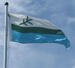
As such, Labrador's flag is unofficial. But it is widely used. 

The top white bar represents the snows of Labrador, with the blue representing the seas, lakes, and waterways which abound across the territory.

The central green bar represents the Spruce tree forests which spread all over Labrador.

In the top hoist corner, there is a spruce tree branch placed over the white stripe. Three of the branches represent the Innu, the Innuit, and the white explorer. The fourth represents the fact that all people are ultimately the same. 

The four branches are arranged into growths. The lower 2 are shorter, representing a hard and arduous past, whilst the longer two represent the hopes for a more prosperous future. 

The coat of arms use many elements found in the flag of Labrador.


The colours on the shield represent the snows/mountains, the trees, and the waters of the territory. The 4 spruce trees represent the four points of the compass. The star represents the Pole star, a symbol of the territory's location as very much a northern territory. 

The supporters are Caribou, animals of historic significance in the lives of the natives, and later, the settlers. Underneath the shield is Caribou moss, and Labrador tea. The crest consists of a Snowy Owl on a wreath of red and gold.

Whether Labradors flag becomes official, we will wait and see!


Tuesday, June 21, 2011

British Columbia


British Columbia introduced its flag in 1960, on June 14, and was first flown on ships of the BC Ferries line. The flag itself features a Union Jack over the top half, defaced by the King Edward Crown. The bottom half features 4 white and 3 blue wavy lines, overlaid by a setting sun.

The Union Jack is placed over the top to represent the old British axiom "Sun never sets on the British Empire." And the crown represents the Canadian Royal family. The white and blue lines represents British Columbia's position as between the Pacific Ocean, and the Rocky mountains.


The setting sun represents the fact that British Columbia is Canada's most westerly province.


Sunday, October 10, 2010

Alberta


Flag of Alberta

Alberta is the 9th province of Canada, being founded September 1st, 1905. It was split from the Northwest Territories. Today, most of the inhabitants live in and around the two main cities of Edmonton and Calgary, both in the south of the province.


The flag of Alberta was first designed back in 1958, and finally adopted on June 1, 1968. The flag itself consists of the state coat of arms on a deep blue field in the centre.


From 1907, Alberta had its own shield. This shield is to be found on the flag today. The shield itself bears an image of the Rocky mountains and the lowlands, grass prairies, and underneath a representation of the provinces main crop, wheat. On top, a St George Cross. Taken from the arms of the Hudson Bay Company, who initially began the development of the territory.


In 1980, Queen Elizabeth augmented the coat of arms with a new crest, supporters, and motto. Now, the coat of arms features a royal helmet with St Edwards Crown, the supporters are a lion and a longhorn antelope. The motto reads Fortis et Liber, meaning "Strong and Free." However, the flag continues to use just the shield from the coat of arms.


Friday, October 8, 2010

Wallis and Futuna


Flag of Wallis and Futuna

The island archipelago is located in the Pacific, north of New Zealand. The archipelago is made up of 3 main islands, and many tiny volcanic islets. The islands where originally charted by Dutch and English explorers in the 17th and 18th centuries, it was the French who actually made moves to settle there, with missionaries arriving in the islands in 1837.


The islands themselves fall under French control, but consist of 3 traditional tribal kingdoms. In 1842, the missionaries feared for their safety, so called for assistance from France to protect them. And with the French military there, the Queen of Uvea (Wallis) signed a treaty in 1887 which turned her kingdom into a French protectorate. 


The group of islands finally where annexed as a group in 1917 and became a full French protectorate, governed from New Caledonia. Then, in 1959, the islands voted to become a French overseas territory. 

The islands, being French territories use the French tricolore as their official flag. However, the group does have its own unofficial flag. Originally, a red banner with the French tricolore in the upper fly hoist edged in white. In the centre of the banner, a white Germanic (Christian) cross.


However, the flag has been altered, with the latest version still being a red banner, with the tricolore edged in white, for heraldic reasons, of not allowing strong colours to touch. However, the cross has been altered. It is now a red saltire cross on a white square. This has been placed to the right of centre, and slightly down.


The coat of arms for the island takes the same form as the flag. The French tricolore placed in the top right corner, and edged in white, with the red saltire on white placed on the lower left.


Saturday, October 2, 2010

St Pierre and Miquelon


Flag of St Pierre and Miquelon

The islands of St Pierre and Miquelon are two French held islands off the south of the Canadian island of Newfoundland. The islands themselves where prized for their rich fishing grounds, first visited by Basque fishermen. However, by the mid 17th century, the French had permanent settlements on the islands.


However, their closeness of the islands to British held Canada proved to be a major provocation to the British, and regular attacks forced the French to abandon the islands. The British took control, and held the islands for 50 years until the French reclaimed them in 1763 under the Treaty of Paris. Which saw them cede control of the rest of their continental Canadian territories.

During the American Revolution, French support for the Americans led to the British to attack the islands, and deport the French settlers. The islands then passed between the French and the British for the next 38 years. France finally took control back in 1815, with the abdication of Napoleon, and there followed a boom in the fishing trade. Leading the island to a long period of wonderful prosperity.

However, the decline in the fishing industry was brought about by political and economic changes, until 1920, when the islands became an important centre for the importation of alcohol into the US with the advent of Prohibition.


The islands themselves are damp and windy, enjoying short, but warm summers, and long, cold, wet winters. 
For many years, cod fishing was most important. However, heavy over fishing of the Grand Banks led the Canadians to close fishing down. Whilst the fishing fleet on the island is French, the Grand Banks are Canadian, which means the fishing fleet has been heavily affected.

Recent attempts at diversification have been under way. Such as agriculture, crab fishing, and tourism.

The islands themselves have their own flag. As a territory of France, they fly the French tricolore. However, they do have a flag of their own.

This flag represents the history of migration to the islands. the main image is a golden ship on a blue background, over the sea. This represents the islands maritime history. Along the fly are three small flags. The top one is a white cross laid over a green diagonal cross on a red background. This is the Basque flag. 


The second one down is a white banner with black arrowheads arranged over it. This is taken from the flag of Brittany. The Brittany flag places this in the upper hoist canton, and has black and white horizontal stripes arranged over the rest of the flag.


The final flag is two golden lions emblazoned on a red field. The flag of Normandy.


These three flags represent the three early waves of immigration into the islands from France.


Saint Martin


Flag of Saint Martin

Like its near neighbour, St Barts, Saint Martin used to be governed as a commune of France from Guadeloupe. However, the island, like St Barts, voted to break away, and become a separate collectivity of France. A process completed by 2007.

Initially, the island was coveted by the Dutch and the French, even though it had been charted by Spain first. They had decided that the island was a low priority. The Dutch where the first to make a move, and established several successful settlements on the island. 

In 1633, the Spanish, already at war with the Netherlands, seized the island and tried to develop it themselves. However, their attempts proved unsuccessful, and they abandoned the island in 1648. After the Spanish withdrawal, both the Dutch and the French jumped back in, and established their own colonies.

Not wanting to face war, both sides signed the Treaty of Concordia which divided the island between them. 1 legend has it that to decide how much went to each side, a race was organised between a Frenchman, and a Dutchman. The Frenchman imbibed in wine, whilst the Dutchman enjoyed Jenever, a Dutch gin. Both set off from the start point, and headed round the coast. Where they met, would be where they drew the line to, from the start point.

Unfortunately for the Dutch, their competitor met a cute lady, and slept off his drinking, whilst the Frenchman cheated and cut a corner off. This meant  that the island was divided in Frances favour.

However, this is only legend. The real reason is that France had a thumping great fleet in port. Makes for a brilliant bargaining chip!


Over the years, various border disputes between the Dutch and the French has ended up with the French holding about 21 sq miles, and  the Dutch, just over 16.

Like many of France's overseas territories, it does not have its own flag. However, it does on land, use its coat of arms on white. There is also a locally designed flag, featuring a white "Y" shape dividing the flag between 2 blue halves. In the centre of the flag is an inverted red triangle, as well as golden half circle.


The coat of arms itself features a ship, a sun, a bird, and a palm tree. As well as the territories name.